Urban Typologies
A typology is a method used to categorise entities according to shared characteristics. The UP2030 Urban Typologies framework classifies European NUTS-3 regions based on features related to urban planning, climate change mitigation, and adaptation. By grouping European cities and regions with similar attributes, the Urban Typologies aim to support these areas in identifying relevant strategies for achieving climate neutrality and resilience.
The UP2030 project has developed four distinct Urban Typologies, each grouping NUTS-3 regions based on similarities in specific characteristics.
To explore the typologies, use our interactive map:Urban Typologies map
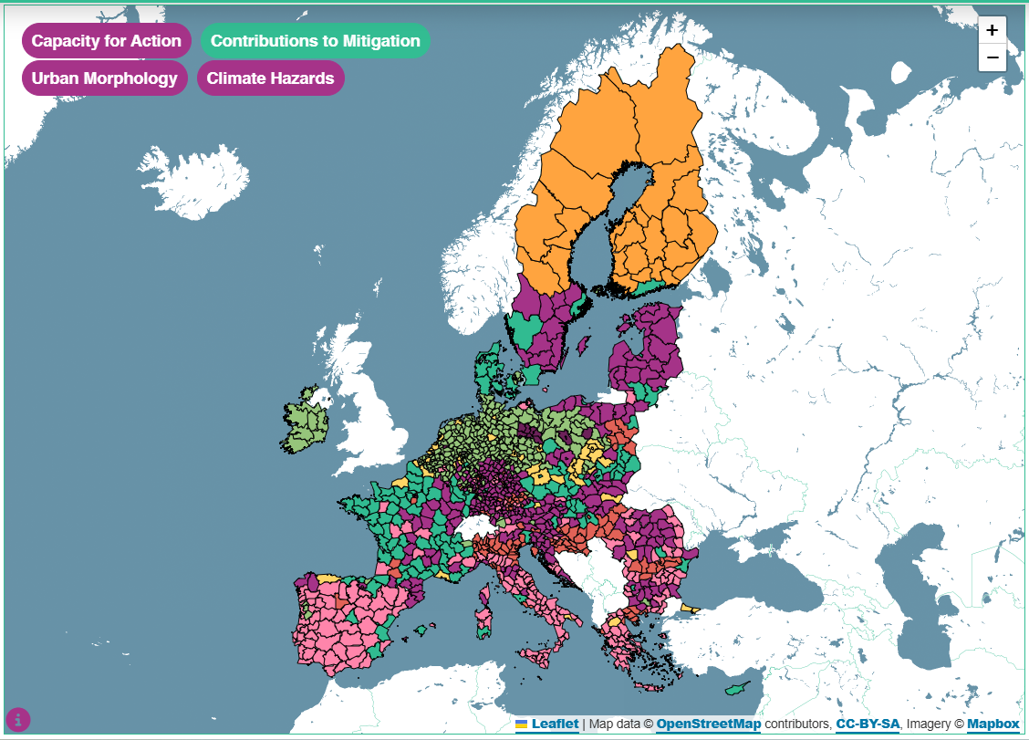
Example view of the interactive map with the "Contributions to Mitigation" typology selected, displaying regional variations in mitigation potential across Europe.
What are they for?
The Urban Typologies provide a robust framework for exploring the diverse characteristics of European regions, particularly regarding climate resilience and potential pathways to net-zero. They enable regions and cities with similar opportunities and challenges to recognise one another, fostering connections, collaboration and mutual learning. Each typology highlights common challenges and opportunities within its clusters, as well as key areas for action. In doing so, the framework empowers urban planners and decision-makers to identify strategic priorities and address climate challenges more effectively.
Key objectives of Urban Typologies
1) Identify similarities between regions to foster collaboration
2) Encourage knowledge-sharing and communication for more effective solutions, especially between regions and cities sharing similar opportunities and challenges
3) Support urban planners and decision-makers in tackling climate change by identifying key challenges, opportunities and action areas with high relevance for future measures in specific clusters
Methodology: How the Urban Typologies were developed
The typologies were created using a well-established methodology with a cluster analysis at its core. The cluster analysis is a statistical method. It groups units, in this case NUTS-3 units, based on similarities, so shared numerical characteristics.
Why use NUTS-3 regions?
For reasons of data availability, it was not possible to conduct the analysis at a very fine scale (i.e., cities only). As an alternative, the NUTS-3 unit of analysis was chosen.
The NUTS classification (nomenclature des unités territoriales statistiques) divides the EU into hierarchical levels, with NUTS-3 being the most detailed. It is a well-established standard unit of analysis used for the development of EU regional policies and socio-economic analysis.
Using NUTS-3 as scale of analysis provides multiple benefits:
- The NUTS-3 regions integrate existing administrative boundaries, meaning that the findings are more directly relevant to policy makers
- It allows cross-border comparisons of urban trends
- It ensures consistent data availability across European regions
For advanced users, the full methodology is available here.
Urban Typologies and the 5UP Approach
The Urban Typologies align with the 5UP Approach for strategic climate planning and are particularly beneficial in the following areas:
UP-DATING
- Helps cities determine which cluster they belong to
- Provides a starting point for needs assessment
- Identifies regions with similar challenges to encourage collaboration
UP-SCALING
- Helps cities expand climate strategies by identifying potential barriers and solutions
- Supports net-zero and climate-resilient city transitions
UP-TAKING
- Enables targeted dissemination of best practices
- Strengthens collaboration between cities in the same cluster
Click on this link to learn more about the 5UP Approach.
Guide: How to use the Urban Typologies
You can access the guide on how to use the Urban Typologies map here.
Partners involved

Contact details
Julia Bartsch - bartsch [at] adelphi [dot] de (bartsch[at]adelphi[dot]de)
Frédérique Tougas - tougas [at] adelphi [dot] de (tougas[at]adelphi[dot]de)
Till Sterzel - till [dot] sterzel [at] greenadapt [dot] de (till[dot]sterzel[at]greenadapt[dot]de)
Carsten Walther - carsten [dot] walther [at] greenadapt [dot] de (carsten[dot]walther[at]greenadapt[dot]de)
Kazi Sajjad Hossain - kazi [dot] hossain [at] greenadapt [dot] de (kazi[dot]hossain[at]greenadapt[dot]de)